0
A'
V
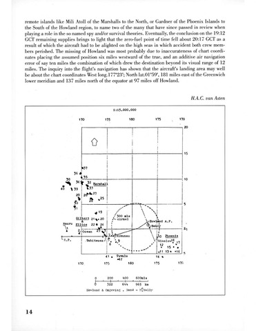
remote islands like Mili Atoll of the Marshalls to the North, or Gardner of the Phoenix Islands to
the South of the Hovvland region, to name two of the many that have since passed in review when
playing a role in the so named spy and/or survival theories. Eventually, the conclusion on the 19:12
GCT remaining supplies brings to light that the zero-fuel point of time fell about 20:17 GCT as a
result of which the aircraft had to be alighted on the high seas in which accident both crew mem
bers perished. The missing of Howland was most probably due to inaccurateness of chart coordi
nates placing the assumed position six miles westward of the true, and an additive air navigation
error of say ten miles the combination of which drew the destination beyond its visual range of 12
miles. The inquiry into the flight's navigation has shown that the aircraft's landing area may well
be about the chart coordinates West long.l77°23'; North lat.01°59', 181 miles east of the Greenwich
lower meridian and 137 miles north of the equator at 97 miles off Howland.
H.A.C. van Asten
ft
I
14
170
1:15.000.000
175 160
•37
36#
35
38 T—
40 39 *3'
Kara hall
29 j 2^^27
Gilbert 21 20
Nauru Elltce 22 24
Ocean 2^
"R.P.
300 mis
- cirkel
Vftfikunau
Tabiteuea-'P. 9
6
*1^
175
üowljand A.P.
Bak,er
170
41 Tuvalu
«42
175 180
170
20
15
10
El
10 Phoenix
•Winslow16
12 .c
15
•11 13 *16
14
175
170
200
322
400
600mls
644 965 ko
Howland Oageving .Rand - M^Nally